NagarMatrix Ventures Pvt Ltd | Urban geospatial services & municipal software
+91 95023 53944|info@nagarmatrix.com
Home/Services/GIS Base Map Preparation

GIS Base Map Preparation

Parcels, buildings, roads, drains and utilities on a clean, documented schema that your department can maintain after handover.
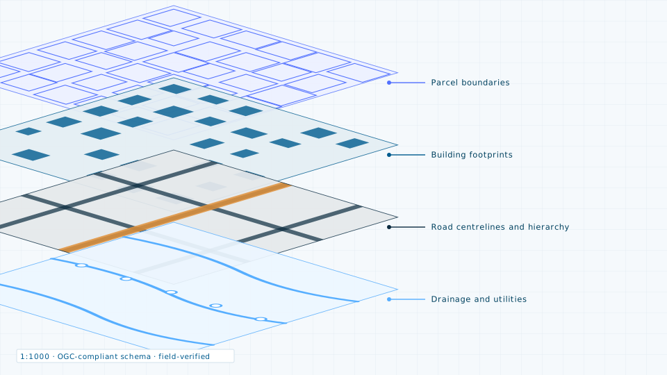
GIS Base Map Preparation — illustration of a typical deliverable
Typical deliverableThe layer stack that makes up a municipal base map — parcels, footprints, roads and drainage.

Most municipal GIS projects fail after handover, not during delivery, because the schema was never documented and nobody was trained to update it. We treat the schema as part of the deliverable: attribute domains, topology rules and an update procedure, written down.

Digitisation runs from high-resolution imagery and is then field-verified, so the map reflects what is on the ground rather than what was visible from above on the day the scene was captured.

What you receive

  • Parcel and holding polygons, topology-clean and gap-free
  • Building footprints with use, floors and structure type attributes
  • Road centrelines and edges with hierarchy, width and surface
  • Drain network with type, section and connectivity
  • Utility layers as available — water supply, street lighting, electrical
  • Points of interest, ward and zone boundaries, landmark features
  • Schema documentation, metadata records and staff training

Specification

Mapping scale
1:1000 to 1:4000
Imagery source
Sub-metre satellite or UAV orthomosaic at 2–5 cm
Verification
Field survey of every ward, with a sample re-check for QA
Standards
OGC-compliant; aligned to NUIS and state GIS specifications
Output formats
SHP, File Geodatabase, GeoJSON, PostGIS, WMS/WFS services
Typical turnaround
10–20 weeks for a small to mid-size municipal area

Typical applications

  • Property tax base expansion
  • Master plan and zoning base
  • Asset and utility management
  • Service delivery planning
  • Municipal software base layer
Request this service
Quote turnaround2 working days

Need the data instead?

If a survey is more than the job requires, the data store lists 84 licensable imagery, elevation and vector products.

Open the data store

Related services

Urban Planning

Urban Planning

Master plans, land use plans, zoning schemes and Local Area Plans.
Planning a gis base map preparation?

Send the site extent and the accuracy you need. We will come back with a scope, a deliverable list and a price.