NagarMatrix Ventures Pvt Ltd | Urban geospatial services & municipal software
+91 95023 53944|info@nagarmatrix.com
Home/Services/Groundwater Study

Groundwater Study

Field observation combined with satellite time series to show where the water is, where it is going, and where recharge will actually work.

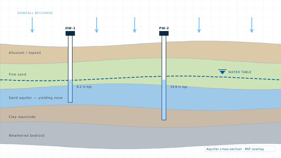
Groundwater Study — illustration of a typical deliverable
Typical deliverableAquifer cross-section showing the water table, screened intervals and recharge.

Source sustainability decisions get made on thin evidence far too often. A groundwater study builds the evidence: water level records from observation wells, lithology from available logs and resistivity sounding, rainfall and land cover from satellite time series, and terrain and drainage from the DEM.

These layers are combined by a weighted overlay — multi-influencing factor or analytic hierarchy process — into recharge potential and groundwater prospect maps, with the weighting method documented so a reviewer can follow the reasoning.

What you receive

  • Pre-monsoon and post-monsoon water level maps with fluctuation analysis
  • Groundwater potential zone map with the weighting scheme documented
  • Recharge potential map and recommended recharge structure siting
  • Land use, slope, drainage density, lineament and soil thematic layers
  • Long-term trend analysis where a sufficient observation record exists
  • Technical report suitable for inclusion in a DPR or research submission

Specification

Analytical method
Multi-influencing factor and analytic hierarchy process overlay
Satellite analysis
Google Earth Engine time series on Sentinel and Landsat archives
Field input
Observation well levels, lithological logs, resistivity soundings
Thematic layers
LULC, slope, drainage density, lineament, soil, rainfall, geomorphology
Output formats
GeoTIFF, SHP, CSV, PDF report
Typical turnaround
6–14 weeks depending on field observation scope

Typical applications

  • Source sustainability assessment
  • Borewell and recharge structure siting
  • Water supply scheme planning
  • Watershed and aquifer management plans
  • Academic and peer-reviewed research
Request this service
Quote turnaround2 working days

Need the data instead?

If a survey is more than the job requires, the data store lists 84 licensable imagery, elevation and vector products.

Open the data store

Related services

Drainage Study

Drainage Study

Catchment delineation, storm-water network modelling and flood risk mapping.
Planning a groundwater study?

Send the site extent and the accuracy you need. We will come back with a scope, a deliverable list and a price.